CLICK to return to previous episode
I awoke at 7am, but it was too cold to get out of bed until 8:15. It occurred to me that I should actually drive up Norwich Road to the North Country Trail’s trailhead and park there, so as to make my approach up the rear of the bluff more expedient. I ate a sparse breakfast and geared up, this time loading all my sleeping gear into my pack as well as the last of the food.
After a quick check of my trusty treasure map I hit the trail at a fair, though tired clip, and soon realized that it was pretty rolling country through here; lots of ravines and such to cross. It took me longer than I expected to make it to the summit of the bluff via this route, but damn were there some fine views along the way:

I think that may be the edge of the Porcupine Mountains in the distance there.
I also refilled my water at the first opportunity.

It took me a few hours to reach it, but once at the fire tower I realized that before me (to the south) was a lower plateau with an elevated ridgeline at its crest, beyond which undoubtedly contained the cleft of the Norwich Mine's B shaft:

I hiked on, realizing that I would have to go basically to the stamp ruins again, and bushwhack south from there until I hit the south face of the bluff. After that I could go off the Norwich Road itself to guide me into the B’s cleft, seeing that the road seemed to point directly to the B shaft. It took a few more hours to hike, but it worked out with no problem.
At one point while I was eating lunch, I suddenly heard voices and froze to listen. The voice I could hear the best belonged to a female, but did not sound like the “hippy” lady I had met Tuesday. I listened as they traveled through the lowland directly south of me, but I knew of no trails that led through there—whoever they were, they were bushwhacking. Interesting...
I continued on for a few hours, and once I reached the stamp’s ruins I kept going south by compass, bushwhacking through the woods. About a half hour later I heard voices again. I froze and waited to see movement. It was a girl—possibly the same one I heard earlier—and someone else. No, it was two girls. I continued forward to meet them and they noticed me with a moment of startled surprise. They hailed me and asked me if I was looking for the trail—that’s when I noticed they were with the Forest Service! I replied no, I wasn't looking for the trail, I was looking for the “Norwich A.” They were confused; they said they knew of no such mine, but that the Norwich B was in the direction I was headed. We were still about 50 feet apart, with plenty of brush between us. I said I had been at the B a couple days ago, but there was also a shaft about 100 yards directly north of it on top of the hill that I assumed was the A, though it was not marked or fenced off at all.
They were obviously very intrigued by this weirdo they had just ran into in the woods, and after a brief pause where I could hear them murmuring amongst themselves, started to ask me more questions. “You’re here alone?! Ya look like you’re geared up for some pretty serious hiking; how long you been out here?” I walked over to where they were and proudly, dramatically unfolded my map…they were as wide-eyed at it as I first was, ha! They both crowded around and started analyzing it, marveling at how many things were labeled on it.

They asked if I was sure I had seen a mine there and I said yes, and that it was totally unmarked. That’s when I noticed they were both carrying yellow tags, GPS units, zip-ties, pink ribbons, and other such items—they were the ones that had been marking all the shafts for capping! The pink ribbons had to be for marking out the easiest paths that could be used to bring materials to the sites via ORV. They admitted “Yeah I’ve definitely never seen that one before…wow, not even fenced off, you say?” Suddenly I regretted offering up my information so quickly. I told them the map was given to me by two people I had run into a couple days ago, but I didn’t know where they had got it from, only that they were using it to find the McDonald shaft. After thinking for a moment, the girls decided that the McDonald must be what they knew as the Norwich D, and that it was just east of here...I was learning all kinds of stuff now.
The two girls talked amongst themselves for a minute, deciding that they had to come see what I was talking about, and asked whether I minded if they follow me. Damn! Now I regretted mentioning it. I had second thoughts about giving info to them—would I be contributing to the destruction of a mine that otherwise might have escaped notice? I mean this one wasn’t even fenced off—was it possible that the USFS had never known about this one…? The two decided that first they had to finish up something on what they called “the lollipop trail” (I assumed that referred to the pink and black striped ribbons), then they would meet me over by where I was talking about. We parted ways and I decided first to locate the cleft of the B, which was easy enough, and I set my pack down there. From there I went by memory, and I thought briefly of trying to waylay the two foresters by pretending I couldn’t find the shaft again, but just then I saw the rock pile come into view again and I heard the girls come up behind me. Oh well, I guess there’s no way to stop the Forest Service from finding and destroying it anyway; they’ll get it in the end regardless of what I do.
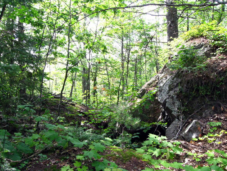
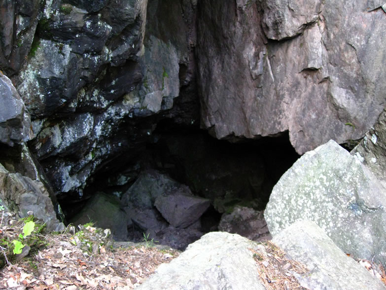
Through the trees here you can make out the grey slope of what appeared to be a tailings pile around what I presumed to be "Norwich A:"

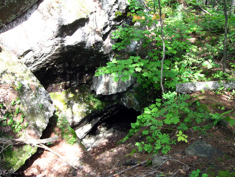
They excitedly scurried up to the opening and began examining it with the same confusion that I had; as it turned out this was probably just another caved stope, not an actual mine shaft. To what mine this stope could've belonged was anyone's guess, however. Though again, there were definitely what appeared to be those tailings strewn down the slope here...maybe it was actually one of the ancient aboriginal mines?
The ladies confirmed that indeed they hadn't known about this one, and decided that they might as well record it even though it was not shown on their map of assigned targets. They both started breaking out their meters and measuring devices and such…one wondered aloud if this mine was shown on a certain report done by a different ranger earlier in the year, and were excited to get back to the office and see if their boss knew about it either.
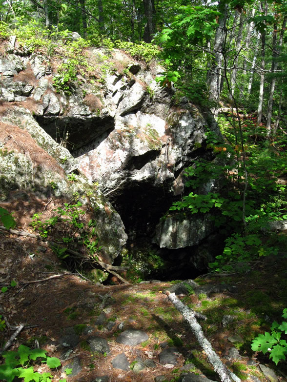
The one writing the data on the tablet looked back at me and laughed, "Well, you get to name this one," and wrote down "Norwich A" on her map. Fitting, since my name starts with A.

I smiled a bit, and as I looked down into the hole they were measuring, I could envision the prehistoric Great Lakes aboriginals who chipped away at the edges of this pit with fire and hammer to obtain the sacred miskwaabik...I was more sure than ever that this was actually not one of the white man's mines. At least, in my mind anyway. It was so shallow...barely 30 feet according to the girl who took the depth reading.
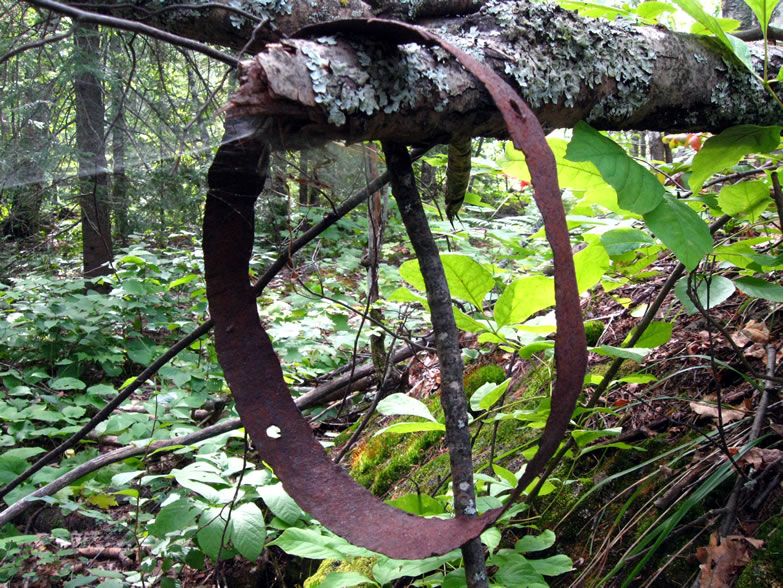
Nearby however I found an iron band, that might have gone to a barrel or a kibble (a primitive bucket for hauling ore from a mine), which is definitely something that white men used:
The girls asked if I had checked out the Norwich B, and I said that I had, but I couldn’t find the adit at the bottom. The more knowledgeable girl asserted that it had been covered in tailings long ago. She also mentioned that the B shaft started to level out some once it had gone down a ways, which I found interesting (I kind of had to wonder how she knew that). With that they had to get going, and asked if I was camping up here. I said yes, that I was going to sleep somewhere in the vicinity of the B shaft, and they told me that it was supposed to rain tonight. I shrugged and said I had it covered, so they wished me good luck and we parted ways.
I returned to the Norwich B shaft, near which I had left my backpack a few moments ago, and continued my attempt at accessing it from behind, this time (to take some more pictures now that the sun was higher in the sky and cast more light down into the opening). Ever so gingerly I made my way like a mountain goat onto lower and lower spots to stand, until I was directly adjacent to it:
Even though this was harrowing and strenuous, it was still preferable to climbing directly up the face of the bluff again. At the mouth of the B, I was again struck with the same awe as the first time. I spent at least another hour or two sitting on top of the massive boulder that had landed in front of the mineshaft's mouth, enjoying the cool air issuing out of it. It kept the mosquitoes away, and provided an excellent spot for quiet reflection on everything I had thus far seen on this expedition, the interactions with the two Forest Service ladies, and what it all meant.
Once I had rested sufficiently and evening started to wear on, I began to have thoughts of moving and perusing the general area for any other cool things that might be found before I would have to make camp. I strapped on my backpack, left the Norwich B behind, and hiked the short distance to a tall bare bluff which I thought might be suitable for sleeping. It was covered in lichen and I noticed all kinds of big ants roving around; plus after standing there for some time testing it out, I noticed the mosquitoes started coming after me. So I moved down to a slightly lower stone table about 30 feet away that had a better view out over the valley.
There were still the ants, but I guess this was inevitable since they no doubt liked the heat retention of the rock, which bakes all day in the sun. Incidentally, this was also my own reason for choosing it. Oh well, just so long I keep my food far separate from my sleeping area, I should be fine. In fact I pulled out the bag of Trenary Toast and sprinkled the cinnamon sugar dust from the bottom of the bag in a spot about 20 feet from where my sleeping bag would be. Hopefully this would lure them away from my spot for awhile. I hung my backpack with the food from a tree and started to wander down the slope a bit to the western face of the bluffs, in hopes of finding the McDonald shaft—or, as the girls had called it, “Norwich D.”

Within two minutes I came across a yellow tag on a tree reading “Norwich Staging Area D.” Before I realized that this might refer to the place where the USFS might be staging some of their shaft capping activities, I took it to literally mean that the Norwich Mine company used it as a staging area for…something. So I started looking around for ruins, but found none. I did however find the Norwich D shaft, or a shaft that was tagged as such:


Slowly I meandered back to my little campsite, and rolled out my sleeping gear. I ate dinner, which was the last of the food except for the four slices of Trenary Toast that would be my breakfast. Tomorrow’s plan basically was only to try and see if anything resided on the west side of Norwich Road before heading back into civilization…if I ended up needing more food in the meantime, there was an MRE that I always kept in the trunk of my car in case of emergencies.
I thought about the rain that the two USFS girls had predicted, and I got my poncho out and ready to go. I also draped my backpack in its own plastic protection before laying down. I had my heavy wool Dutch Army blanket in my sleeping bag. As I watched the waxing quarter moon rise over the darkening forest, I noticed the mosquitoes start to come after me again. I killed them off one by one, and luckily was never swarmed. However they just would not relent. I was extremely anxious for the sun to set so that the temps would fall and drive them away. Despite what you would think about sleeping on an exposed clifftop, there was not even the slightest bit of breeze to thwart them either. I had really counted on that, but not a leaf stirred in all the forest as I battled angrily with the bastards. Now I prayed for the rain to come all the sooner, in hopes that perhaps that would tame them.
Once total darkness had finally fallen, I could see the clouds rolling in and after another hour or so the drops at long last began to fall. “Miigwetch,” I said with a smile, as I rolled out my poncho. I might actually get some sleep after all tonight. The rain took awhile to get going after some starts and stops, but the mosquitoes did in fact relent. However, the rain then began to fall fairly seriously. Then it started to fall kind of…harder than I was hoping it would…and it didn't show any signs of letting up any time soon.
Then I suddenly realized that this poncho setup that had worked so well on North Manitou Island was definitely not holding up to the test…. I could feel the parts of my bag that were on the edges of the poncho begin to get wet. “Oh well,” I thought, “I guess I’m going to get a little wet tonight.” I tried to go to sleep anyway, just as I had on the island. It didn’t work. Somehow, and I still do not understand this, but the plastic poncho began to leak on my face…and the water was very cold. I now came to the realization that this would be no gentle evening rain shower. I used my hand to create a tent in the poncho over my face to maybe help keep the water from pooling and draining onto my cheek. This merely caused the edges of my bag to get wetter. I tried my best to ignore it and just get some sleep. Now the wind began to pick up a little. This could get ugly, but I didn’t let myself think about it. All that mattered was that I was still mostly dry and warm under the main part of my sleeping bag, and that I needed some sleep.
Time went on. The rain started hammering down on the mountain in ice cold sheets. Groaning in protest, I scrunched up in my bag, abandoning the edges of it, and trying to just get comfortable enough to get a few hours of sleep. Then, like an icy dagger, I felt the first trickle of cold water infiltrate the underside of the sleeping bag near my butt, instilling me with the first pang of real fear…I had problems. However, in the fatigued, half-asleep state I was in, I just concentrated on trying to get some rest and make it ‘til dawn. It couldn’t be that far away after all.
That was my first mistake.
The trickle soon became a widening wet spot under my butt, and I rolled to my left side, trying to minimize contact, and ignore it. I was still quite warm inside here other than that one butt cheek, so I let it slide, despite my mounting misery. The rain pounded harder, and I was getting splashed in the face from the spray off the ground around me. The poncho weighed heavily and coldly on my face, leaking all the more. I told myself this couldn’t last much longer; pretty soon it will be over and I can pass out ‘til dawn.
That was my second mistake.
The rain continued unabated, as did the wind gusts, and I occasionally peeked out of my little cocoon to see if dawn was coming yet. Nope. Just pure darkness out across the blotted-out forest below. I tried to scootch my bag into a better spot to avoid the little river of water that was coming in, but this was no use. I tried coming out from my shelter a bit to move it, but as soon as I did I got hosed by the ice cold deluge, and for fear of wetting the last dry spots of my sleeping bag, I retreated back inside and drew the poncho back over myself. I pondered breaking camp and hiking back to my car to finish out the night, but bushwhacking in the dark over unfamiliar terrain while getting soaked and buffeted by cold wind? I’d never make it. No way. I’d end up lost and freezing to death. My best bet was to stay where at least it was warm and still comparatively dry. I puzzled this out for quite some time over and over in my head, trying to make the best judgment call in my hazy half-conscious state. After a little while, the rain seemed to abate back to a mild sprinkle. This caused me to relax my concerns a little, and go back to trying to sleep again.
That was my third mistake.
In about a half hour, it began to downpour again. I cursed out loud, wondering how much longer it could possibly be until the damned morning light. This was the most miserable I had ever been while camping, ever. Suddenly I felt a new river cut through a formerly dry spot under my shoulder. I was now starting to become afraid of hypothermia. I scootched myself over to let it pass, and I was now hemmed into an increasingly smaller viable area. How much longer could this go on?
The wind suddenly howled up the cliffs at me and I could feel the cold cutting through. The rain poured even harder, and yet another breech brought water into my bag. Soon a good portion of my upper body was moist, and my arms were wet. The top of my sleeping bag was wet also from the compromised poncho. This was like one of those old war movies where the submarine crew is running around trying to stop the leaks every time a depth charge goes off. The problem was that I had unwittingly placed my bed on what I thought was a flat rock, but which actually had a very slight, almost imperceptible bowl shape to it, causing it to collect water under my ass. This was a major problem. But should I risk jumping out in a torrential rain squall to move my bag, and getting even more soaked? No, I thought; my feet were still bone dry, and they were quite warm, which made me very happy. If I got out now, I would have to go through the awkward and time-costly process of getting my boots on, then taking them off again to get back in, during which time both feet and boots would get wet, which I could not risk. I decided to stick it out even further. I was in complete misery…a sopping, nylon f#$%ing sleeping bag sticking to me all over in the cold clammy dampness…this was completely intolerable. There was no way I could sleep now.
The “creek” that had started running past my butt now widened into a raging river. It was basically too late to react to this now, however; the damage had been done. I began to shiver. Suddenly I was struck with panic as I realized this meant I was succumbing to hypothermia, and finally my brain and body shifted out of sleep mode into survival mode. The “H-word” struck fear through me like a knife. My teeth clenched and I focused all my energy on producing heat to stay alive. I pulled the wool blanket over me as much as I could, and hunkered down even further, abandoning most of the bag to the rain.
However, the new state of my mind would not let me think any remotely negative thoughts, because I knew that anyone who has ever survived situations like this did so only through their unwillingness to succumb. I focused myself on survival. I was riding on the very brink of breaking into shivering, and I knew I could not let that happen. Every time I started to think about how ridiculous and unforgivable it was that I had allowed myself to get into this situation, I put those thoughts out of my mind, and thought instead of the nice warm cup of coffee and soup I would be having as soon as I got to the nearest town in the morning. Every time I started thinking about how much this sucked, I flushed that out of my mind too. I knew if I let myself sink one millimeter further into hypothermia I would be facing my mortality. Chances were with this Lake Superior storm unlikely to let up, and the probability that dawn was still quite a ways off, I would only have divine providence left to save me; I decided it was best not to entrust my life to chance any more than I already had, and tightened my resolve. In fact, I’m embarrassed to admit it, but I began to sing a song in my head to keep from losing my spirits—and the Battle Hymn of the Republic was the first thing that came to mind, haha.
I diligently sang it over and over in my head in order to keep from slipping into a stupor. Somehow I stayed warm…for awhile. I drifted through a gray haze of time that lasted perhaps for hours. My consciousness was tenuous at best, but I know I did not sleep. After what seemed like several more hours I broke out of the haze and looked out of my cocoon again to see if even the slightest hint of dawn was showing. I could not tell. I had checked over and over again through the course of the night and each time slammed the poncho back down over me again in exasperation when I saw that it was still pitch dark out. I was in Hell.
I was so fatigued now that I resolved that as soon as the next time the rain even showed the slightest hint of slowing, I was going to make a break for it regardless if it was light enough, or die laying here. God dammit, if I was going to die it was not going to be curled up like a scared puppy in a soaked 1980s-vintage sleeping bag. F#$% the woods, I would jump down the damned tailings pile itself if I had to. Everything I had was completely soaked through. Completely. My pack was going to weigh about six times heavier as a result. I considered leaving everything behind and just making a mad dash for the warmth of my car, but decided against it at the last minute. As I waited, I assembled my thoughts into a coherent plan of action for every thing I would do once I got out of this bag, and the order in which I would do them, so as to save time.
Finally, I detected the driving rain begin to show signs of momentary weakness. I burst out from my clammy miserable prison cell and immediately draped myself in the wet wool blanket, and then the poncho over top. I put my boots on as fast as I could, thankful that they were indeed still dry. Then I dashed over to my pack, uncovered it, and guzzled the remaining mouthfuls of water that were in my canteen before ramrodding the last four pieces of Trenary Toast down my throat. They never knew what hit them.
I was shaking all over, and cursing like a sailor. But I was feeling heat return to my blood from the adrenaline surge that was driving me, and with it confidence. I focused my anger. I rolled up my soaking gear as fast as I could, and stuffed my pack. I lifted the sleeping bag and it alone weighed as much as my entire pack had weighed before. This was bad.
Nonetheless I took off into the woods like I was fired out of a cannon. It was actually kind of seeming like it might be sort of light out…almost like dawn might finally be here…heh. I could actually kind of see where I was going. Swiftly I located the cleft of the Norwich B and bushwhacked my way back to where I had ran into the two USFS girls last evening, eventually back to the trail that led me past the stamp sand, and finally back down the mountain.
My plan was to just go back down the front of the mountain via Miner’s Trail since I now was very familiar with that route, as opposed to the meandering and hilly North Country Trail back-way that I was not sure I could find in the dark. That in fact was one big reason why I had been afraid to get up and leave earlier—I couldn’t remember offhand how to bushwhack my way back to it. But now I was fully confident that I could simply charge down the easy way and just walk the rest of the way around the hill by taking Norwich Road all the way back to my car. It would take forever, but at least I would not get lost. I did have a flashlight, but navigating like that in the woods makes it very hard to judge distances, and that is very important to be able to do when you’re bushwhacking (especially under these circumstances when there is no room for error).
Despite my extreme fatigue and misery, it felt good to be up on my feet and walking again. It occurred to me that probably the one reason I was alive right now was because of that damned Dutch Army wool blanket. Once I reached the Norwich Road a couple hours later, morning was definitely upon me, but the rain would not relent. It was absolutely drenching me to the bone. By the time I reached my car I was spent. I dumped my gear in the trunk, retrieved some dry clothes, and turned on both the heat and the A/C full blast. The outside temperature was 50F. I set my waterlogged articles to dry under a floor vent, dried my dishpan hands at a dash vent, and drove away toward Ontonagon happy I was alive, but completely humiliated. I had violated the Scout Motto and paid the price. I should have been a lot smarter than this.
And now, just to make sure you don’t read to the end of this post and find out there wasn’t any more pictures, I’ll post a few shots from a spot I checked out in Marquette.
I had stopped only briefly in Ontonagon, long enough to get fuel and a large cup of coffee, then I hit the road east to Marquette with only one thing on my mind—lunch and beers at Das Vierling! Happy thoughts of their whitefish chowder and stout beer was partially what kept me going through those last hours of hell on the Norwich Bluff. Once securely ensconced at my usual booth overlooking the harbor and the old DSS&A Ore Dock, I felt myself returning to some semblance of sanity and remembered that there was the ruins of an old dam I had wanted to investigate, north of town.

I'm pretty sure it was that Dan Glass character who had posted pics from the dam I was thinking of on his site, which I found via clicking a link he had posted on Copper Country Explorer's forum. I did some research and narrowed it down to two potential locations…one was along Cliff Power Road, which followed a river that drains into the harbor near a big power station, and I could see some old pipes crossing it on Google Maps, similar to the ones Glass had posted pictures of, and the other was the Collinsville Dam on the north end of town, which I had read about in an EPA or DNR report dated to 2003.
After stuffing myself with much food and drink, I checked out Cliff Power Road, and in fact there was an aqueduct there, but I could not find the ruins in question.

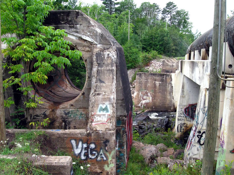
Next I went looking for the Collinsville Dam and quickly realized that I had nailed the location I saw the pictures of:

Though I wasn't really seeing a dam, exactly...

My friend Rutabaga (who actually worked for the Forest Service in those days) has told me recently that there were other dams in this area on the Dead River that failed, and that I might have the wrong name / location. However, you can somewhat see a brick ruin to the left in this next photo, that might have gone to some sort of dam? Though it looks more like a bridge footing:


Looking at it from an aerial map now, I see that it is actually part of a penstock that ran between the Forestville Dam upstream of here and the Forestville Powerhouse downstream, and this round thing that I was standing in was obviously part of another penstock that once ran alongside the existing one, possibly for diverting water to a third pipe, judging by the older footings next to the newer ones:

At any rate, I was now satisfied that I had done a fairly thorough job of finding new stuff in the Yoopee, and decided to make haste for Detroit so as to be able to sleep in a bed for the first time in a week. What a complete flog. Let this story be a lesson—hypothermia is no joke!
As a footnote, I should mention that another member of CCE was out at Norwich Bluff less than two weeks after I was there, and he reported that already the mines I've showed you had been capped. I had been just in the knick of time.
Sources cited in this series:
http://www.coppercountryexplorer.com/explorations/mines/cliff-mine/
http://cliffmine.wordpress.com/history-of-cliff/
http://cliffmine.wordpress.com/2011/05/21/field-trips-part-1-the-norwich-bluff/
http://www.passportintime.com/summaries/96/mi96_ottawa_nwoods.html
http://www.mindat.org/loc-17462.html
http://www.mindat.org/loc-17100.html
Norwich Mine, An Historical Journey Across Time, by Joseph R. Papineau
A Guide to Michigan's Historic Keweenaw Copper District, by Lawrence J. Molloy
"The Copper of Michigan," New York Times, Oct. 14, 1890
"The Ontonagon Copper Rock," Sacramento Daily Union, Oct. 8, 1857
I had stopped only briefly in Ontonagon, long enough to get fuel and a large cup of coffee, then I hit the road east to Marquette with only one thing on my mind—lunch and beers at Das Vierling! Happy thoughts of their whitefish chowder and stout beer was partially what kept me going through those last hours of hell on the Norwich Bluff. Once securely ensconced at my usual booth overlooking the harbor and the old DSS&A Ore Dock, I felt myself returning to some semblance of sanity and remembered that there was the ruins of an old dam I had wanted to investigate, north of town.
After stuffing myself with much food and drink, I checked out Cliff Power Road, and in fact there was an aqueduct there, but I could not find the ruins in question.
These falls are the Lower Dead River Falls, according to Jacob Emerick, but I have also seen them referred to as the Collinsville Falls.
As a footnote, I should mention that another member of CCE was out at Norwich Bluff less than two weeks after I was there, and he reported that already the mines I've showed you had been capped. I had been just in the knick of time.
Sources cited in this series:
http://www.coppercountryexplorer.com/explorations/mines/cliff-mine/
http://cliffmine.wordpress.com/history-of-cliff/
http://cliffmine.wordpress.com/2011/05/21/field-trips-part-1-the-norwich-bluff/
http://www.passportintime.com/summaries/96/mi96_ottawa_nwoods.html
http://www.mindat.org/loc-17462.html
http://www.mindat.org/loc-17100.html
Norwich Mine, An Historical Journey Across Time, by Joseph R. Papineau
A Guide to Michigan's Historic Keweenaw Copper District, by Lawrence J. Molloy
"The Copper of Michigan," New York Times, Oct. 14, 1890
"The Ontonagon Copper Rock," Sacramento Daily Union, Oct. 8, 1857
No comments:
Post a Comment
Note: Only a member of this blog may post a comment.