
May, 2013.
RETURN to part 9
Day 4
I jolted awake when I opened my eyes hours later to the sound of birds chirping, and angrily grabbed my ipod to see that it had been going off for almost an hour, but that because I had turned the music volume all the way down last time I used it, the alarm was also muted. Who designs an alarm like that?! It was eight minutes to 5am…I had already lost an hour. I jumped from the bed in a panic, and groggily tossed everything in my pack, hastily tying it shut before bursting onto the trail to the beach. No coffee this morning, Private Pyle.

The sky had strangely begun to lighten in the north, almost like an aurora, and I could see the lights of two freighters laying at anchor not far from the Lansing Shoal Light's blinking beacon. I could hear their engines idling, and the sound of the fog horn still throbbed every few moments, though whatever fog there had been was now totally gone. I wondered what the deal was, and why the ships were still stationary. Maybe they had accidentally put their ipods on mute like me.

After pausing at the brink of the stony beach to snap these couple photos I then broke into almost a run (or as much of one as you can do with a heavy pack on), making my way to the northwest in the crisp morning air. If I was at a disadvantage for time before, now I was really in a crunch…I just hoped that my calculations had erred on the conservative side. I now had precisely five hours to go about 12 miles. Over rough, rocky, mucky beach.
That's mathematically impossible, I think...according to the internet, most people walk about 2mph on average, and 4mph would be considered powerwalking, almost jogging. To cover 12 miles at 2mph it would take six hours, so to do it in five, I would have to sustain a minimum of 2.4mph for the entire trek. With the terrain I would be covering, and the burden I would be carrying, that was an awfully tall order. Not to mention I would have to stop for rests, and to go get my sleeping bag from the DNR cabin.
I decided that the only way I could make this happen would be if I strategically cut corners by bushwhacking across the longer points of land as opposed to following every contour of the wildly jagged shoreline. Hopefully I wouldn't get myself lost again. Essentially I had no choice but to just catapult myself ahead at the greatest speed possible. But I also had to keep my wits sharp at all times so as to choose the best path over the loose, rocky shore with its intermittent quicksand pits. Every choice I made would affect my time, and my energy levels. All things considered, this was easily the single most challenging hike I had ever undertaken.

As the sun broke over the trees behind me it revealed a glassy Lake Michigan and brilliantly lit terrain. It was a spectacular morning, I just wished I could enjoy it more instead of being so nervous about time. Luckily I was feeling well-rested and totally in the zone, if a little sore in the feet and joints. Actually to be perfectly honest, my feet and ankles were #$%ing killing me from the abuse of rolling over baseball-sized rocks for ten hours yesterday. This little island had really taken me to school.
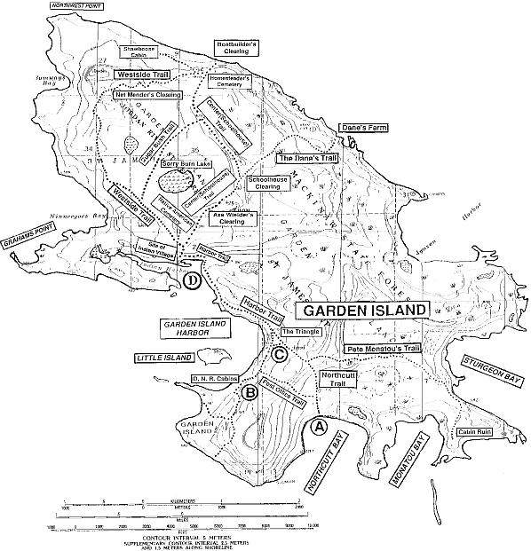
As I passed peninsula after pointy peninsula, I wondered when I would be getting back to the bay where I had popped out yesterday and realized I was lost (whichever bay that was!). That would be a good gauge of my progress. The largest peninsula I would be rounding would be Graham's Point (MAP), which stretched out under the southern end of Nineegoes Bay. After that I would be halfway back to the DNR cabins.
I began slicing across the middle of every point of land that I came to to try and shave every possible minute off of my ETA, vaulting over big rocks and laboriously pushing like an elephant through tangled masses of trees with my pack on. I was getting a major workout…one thing was for sure, when I reached Northcutt I would be spent. I suddenly recognized the bay I was on as the one where I had popped out of the swamp yesterday afternoon. This was good, I was making quicker progress than anticipated. I was also glad that the bugs had not woke up yet to pester me.
I believed that I had finally crossed Graham's Point at about 6:45 or 7am. I wasn't sure, and I definitely didn't want to get my hopes up that I was making that good of progress, because I just knew that it was probably just another nameless peninsula and that another one just as big would present itself in an hour, and yet another after that. By this hour the bugs had now definitely woke up and were beginning to swarm me every time I pushed through another cedar thicket or brushed up against a scrub plant.

Here somewhere near Graham's Point was the location of the Wachtner homestead, once upon a time. William Wachtner, the son of the Beaver Island Lighthouse keeper, came to Garden Island as a fisherman. It was his son, William Wachtner Jr., born in 1902, who served as the main informant to R.H. Ruchhoft when he was seeking out oral histories of Garden Island. So, much of the information I have thus far relayed concerning this island's (white) history came from Wachtner Jr.'s lips. The lives of their family were also "woven into the fabric" of the Vincent family as well, as is common amongst islanders living in isolation.
William Wachtner Sr. married John Vincent's daughter Lydia, and they built a home at Graham's Point. When their family swelled to an eventual total of nine children, they later moved across the island to Peter Jensen's house (which they shared with Little Pete Nielsen and his sister), and some time after that moved again to Naubinway, a small village on the shores of the Yoopee, not far to the north. But they came back to the island in 1907, and moved into the Vincents' house. It is said that when John Vincent died, William Wachtner may have assisted his son Henry in the boat building business until the close of that season. William Wachtner Jr. recalled that in those days there were less than 20 school-age children on Garden Island--including six Vincents, six Wachtners, four Jensens, and three Indians. The schoolhouse on the island was in session only five months of the year; their stint in Naubinway illustrated to him how far behind, academically, they were compared to mainlander children.
In the winter of 1914, William Wachtner Sr. died in the Vincent house, and a year later William Jr.'s wife passed away in the same house. Prior to that, both his father-in-law and an infant child of his had died in the very same house, all within a five-year period. Following the death of his wife, William Jr. decided he had had enough of Garden Island forever, and moved the remaining members of his family to Naubinway once again, moving into a house vacated as a result of the ending of the lumber boom in that region. He lived to see 92, though he never remarried. The Wachtners did still return often to Garden Island in the summer to harvest wild berries. With the departure of the Wachtners, John Vincent Jr. moved from the Indian village back into the traditional Vincent homestead with his native wife. He was the last occupant of that house ever, according to Ruchhoft, and after his final departure from the island, it fell to ruin and has totally disappeared. I did not see any traces of the Wachtner homestead, but I did find this shard of an old glass bottle in the area as I was walking (which I photographed on my table once I got home):

William Wachtner Jr. recalled that in about 1915 when he moved his family back to the Upper Peninsula, there were only about four Indian families remaining on Garden Island. He also added that in 1920, members of the House of David colony on High Island would make Sunday visits to Garden Island in the summertime where they picnicked. In the large open area near Indian Harbor they spread out their various cakes, vegetables, and "gallons of homemade ice cream." According to Ruchhoft, they held baseball games as well, "something which they would not have done if there had still been Indian families living there."
Here was a view of Beaver Island's northern shore directly to my south:

I caught my first glimpse of what I believed might be Indian Harbor at about 7:30am…damn, if that was true, I was making some pretty kick-ass progress.

The heat of the day was starting to build up, and I had begun sweating from my exertion. My hips, and every muscle or joint below them was in real pain from the flog, but it was manageable. I tried to keep the speed on, but I just had to sit and rest for a minute in a shaded glen of spruces here. My shirt was soaked. I ate a few of the last handfuls of trail mix, sipped more water, and put my pack back on.
The spongy expanse surrounding Indian Harbor looked just firm enough that I could maybe cross the marshgrass of the floodplains surrounding the actual water. This was something I had been doing on my entire trek so far, but this was the muddiest. I went as close in as I dared, risking getting sunk and losing time. I managed okay, and was soon up on dry land again, striding painfully but briskly up into a field that looked somewhat familiar….

It was full of old fruit trees, so I thought it must be the old orchard I crossed through when I had gone to the Indian Cemetery. The morning dew glistened in the clean sunlight making the entire field seem fresh and new. I was sad that I was here before spring had really sprung; it must be wonderful to experience these lost ancient orchards when they are in bloom. Suddenly I stumbled upon a series of hewn logs sitting in a square pattern, almost like a cabin or farm structure had once been here. This was not on my map…

Then it hit me--it was the same orchard! There in the distance was the old McCormick mower I had seen early yesterday:

That meant I was probably only an hour away from the DNR cabins! I checked my clock and it was about 7:45am…I actually had a chance to make it to the rendezvous point by 10! I had been making incredible time. Before I let myself get overconfident, I buckled back down and looked at my map, realizing that I still had a lot of terrain to cover, so I continued hoofing as hard as I could muster. I still had to add about 10lbs and a lot of bulk to my load once I retrieved my sleeping bag from the DNR cabin, and it would be another hour from there to Northcutt. I added it all up in my head quickly and realized that unless I was mistaken I would be arriving there with up to 15 minutes to spare.
I soon saw what I thought was the shape of Little Island now in view across the large bay I was circling. Could this really be Garden Island Harbor already? If so, that meant that the DNR cabins were just on the other side of it. I strained my eyes to see if indeed it was a small island I was looking at, but with the current angle of the sunlight it was hard to tell. I put all those thoughts out of my head, and instead of getting my hopes up I decided that it was probably an illusion and that I needed to speed up.
Sure enough, it was an island, and I began to recognize the beach as I came to the other side. There was my fire circle from two nights ago. And here were the cabins:

It was now 8:45am. I finally let myself feel confident that I had somehow pulled it off, and that I was safe from having a search party sent out after me, haha. I still had no plans of slowing down--I needed to make sure that nothing happened between now and then to delay my arrival, but I needed a rest, badly. I came into the cabin and saw my sleeping bag still undisturbed, so I collapsed into the chair by the door.
I was seriously starting to feel like I was coming to the end of my stamina. I ate the last of my trail bread and drank a little more water, and dreamed of the real food and beers I would be consuming back on Beaver Island later today. I was officially sore as f*ck. I sat slumped there as long as I dared, trying to regain some energy. It was an absolutely glorious day outside. Now I felt like I could enjoy it a little more, since I was not quite so nervous anymore. Finally forcing myself to get up, I decided to investigate the other cabin that I had overlooked earlier, before getting back on the trail.

Again the hand-made sign on the door declared that the cabin may be used in case of emergency. And again it had no lock. I slowly pushed the door open and looked inside…


Rows of coffee cups and cooking ware hung neatly from the walls, ready to be used, a kettle on the potbelly stove in the corner. The icebox was the exact same model and vintage as the ones in the DNR cabins on High Island. Everything in here looked like it had been bought at a yard sale in the 1970s.


I also noted the abundance of alcoholic beverage containers about…what was this, a governmental scientific outpost, or a frat boy hunting lodge?

Through the doorway to the rear was where the bunks were.


According to this…meal itinerary, or whatever it was, they had stayed here from November 13 to November 24. I'm guessing the snow was already three feet deep by then.

Alright, enough snooping--I had to get back on the trail. This time at least, I knew I could actually use the trails from here to Northcutt without too much hardship. God almighty, it sure was bliss to feel soft cushy evergreen needles under my feet again instead of hard, loose rock. Now was the last leg, my final sprint in the race against the clock.
I poured on everything I had into one last burst of power, diving through fallen trees and traversing over the downy trails. As I neared what I knew to be Northcutt Bay through the trees, I could hear the sound of a boat motor. I looked through a sudden window in the trees, and saw the giant "V" shape of the wake from a boat pointing toward shore--it was Jon--and he was just arriving!

I nearly collapsed on the beach from relief and exhaustion, but managed to take this one last photo, with a huge contented smile on my face. Guess what the time stamp on this .jpg was?
9:59am.


CLICK for part 11
References:
Exploring North Manitou, South Manitou, High and Garden Islands of the Lake Michigan Archipelago, by R.H. Ruchhoft
Spellbinding to the author! I am in the process of writing a book on Garden. We first hunted there in 1970 as The Garden Island Six from Ohio. Since moved to Michigan in 83 and will celebrate or 50th Anniv. this year. My focus is toward our group and others that we shared the island with. I have been on every trail and recognize so much of your story. In the early years the trails were mostly cleared and the deer hunting was great! A lot has changed and nature has taken back what is hers. Compliments to you on a fine presentation!
ReplyDelete