
CLICK to return to previous episode
I arrived at Norwich Bluff again later than I wanted, at 1:30pm, and the weather was clearing up (MAP). I got out my full-size frame backpack this time, and stocked it with a few more items, especially lunch and dinner. I left out my sleeping gear however, as that would save me a large amount of weight and bulk for ease of maneuvering through heavy brush in my explorations today. Since I was going to be camping at my car, I didn’t need to bring them. As far as water went, I had filled up in Calumet, but I knew now that there were a few sources here that I could utilize, so I should do okay on hydration. This time I also got out my hiking socks, since I’d be going a little more hardcore from here on out.
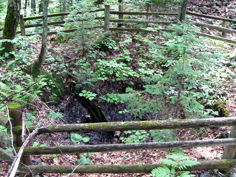
I knew exactly what route I would take this time—back up the Miner’s Trail to the cut where the “interp. trail” was marked, since that was the one that corresponded to both ROC’s descriptions and the faded map by the fire tower ruins. Instantly I started to come upon more of those fenced-off mine pits on rises alongside the trail:

The wooden fencing was old, and in some cases enclosed an even older row of fencing that had now become so decrepit it was falling into the shaft itself as the hole widened.

About half the time I was able to locate a ribbon marker that presumably identified the name of the shaft. Perhaps those unmarked were the more ancient pits?

They sure looked fairly unsophisticated and I could find no surface ruins accompanying them. I doubted these shafts were very deep. Still though, they looked scary for the most part—no place that I’d like to be stepping too near. Very weak and crumbly, prone to caving.
Often around the mouths of these shafts I’d find specimens of quartzite and amygdaloidal copper; wherever you find quartz, you’re sure to find precious metals in the same vein. There are two kinds of copper that you can mine—pure, and amygdaloidal (which is the stuff that’s mixed in with quartz or other minerals). Obviously the amygdaloidal is less rich and costs more to process and extract, but it is by far the more common type.

Though I knew nothing of it at the time, a small, independently published book had been written on the history of the Norwich area mines, by Joseph R. Papineau. In it, Papineau says that the first early exploration into this land was by the American Mining and Manufacturing Co. in 1845, when they sent out a company of relatively inexperienced men to explore their newly acquired permit lands, led by Alonzo C. Davis. The nearest established port for the schooners that would bring new immigrants here to explore into the wilds for copper was the village that would eventually become the city of Ontonagon we know today, and Norwich Bluff is located about 20 miles directly south of it through complete wilderness. Ontonagon is also where the nearest Governmental Mine Agency Office was built, by order of Gen. William Cunningham in command at Fort Wilkins.
On July 15, 1846, Davis and his seven-man crew made their first discovery of red metal. They unearthed two masses of pure copper, totaling about 125lbs., and emboldened by this discovery, dug in with even more enthusiasm and complete a 60-foot shaft in about a few weeks. The Cliff Mine was already receiving worldwide fame for the copper discovered there that same year, which only heightened the copper fever in Michigan. Those Norwich men not on the clock underground were busily constructing a few log cabins to prepare for the cold weather that would soon come.
However the copper seemed to dry up quickly in this first location, Papineau noted, and work was stopped by the onset of winter, not to resume until spring 1847. In those days most fled the untamed Ontonagon lands before winter, since survival here was just too daunting back then, and mining activities generally stopped in winter anyway because the water used in the stamp mill process would freeze. Besides, the only refuge anywhere in the land that would soon come to be known as Copper Country was the Army’s newly-built Fort Wilkins 100 miles away, at the northernmost point of the Keweenaw. Life at Fort Wilkins was probably not much easier, however. There was no law anywhere else in this frontier land, as counties and sheriffs had yet to be established; Copper Country was very much the predecessor to the Wild West.
Papineau also says that when spring finally broke, many of those who had chosen to “tough-out” the winter were found waiting on the docks at the lake ports for the first ship out, to “sail away, never to return to this ‘godforsaken’ wilderness.” Others were found waiting to be buried once the ground had thawed sufficiently to dig a grave. By mid-1847, there were 124 mines established, and business at the mine agency office continued to be brisk. The Ohio Trap Rock Mining Co. moved to their Norwich bluff location here in 1849.

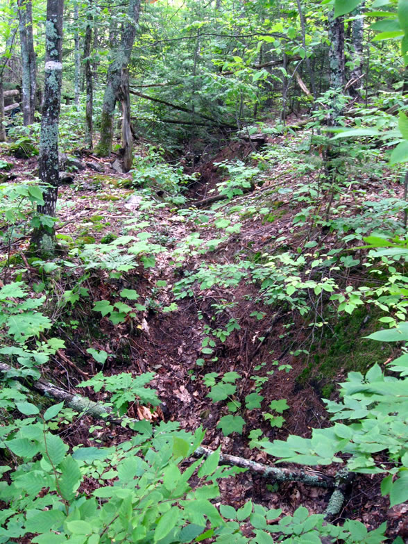
As I hiked westward toward the ruins of the stamp mill, I saw more and more pits or cellar holes along the trail, sometimes a couple next to each other. Then I came upon a series of four unmarked openings that were so close together that they almost formed a trench:

Again, they all seemed to be sunk at about a 45-degree angle, though they were so caved in and clogged with leaves it was hard to tell. I zoomed in on a couple to see inside:

Here we can see the fragility of the ground in the vicinity; I wanted to be careful where I walked so as not to fall through the ground into a sinkhole:

And here, well outside the fenced area, we can see where there is a fissure opening up due to the ground pulling away behind one of the other older, fenced openings:

When a mine is about to close down, they will finish by going back and removing the last bits of ore that can safely be taken out of the stope ceilings, which often weakens the mine's structure, and can cause cave-ins. These elongated cracks I was seeing in the ground formed because the stopes of the uppermost level of the mine under my feet had either been stoped straight out to daylight, or because they had caved in.

Kinda spooky how fragile and porous the ground was around here. Clearly there was a vast subterranean labyrinth beneath my feet in the honeycombed bosom of Norwich Bluff. Look at this crazy spot getting ready to cave in and form a new fissure...
Further on, the trail started to weave down into a small valley before coming up again to the next bluff, and another shaft alongside the trail was found:

This one was even more overgrown.

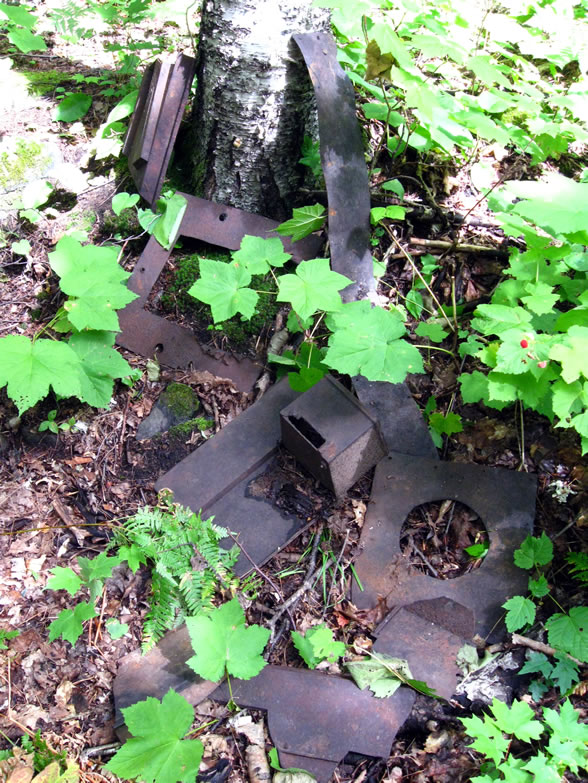
Almost immediately down the trail from there was a fork in the road, surrounded by debris from a boiler or some old piece of Steam Age technology broken up into fragments and strewn about the forest floor:

In spring of 1850 Papineau states a new vein was discovered at Norwich, and Alonzo Davis incorporated the Norwich Mining Co., as a new unique entity under the auspices of the American Mining Company, who by 1855 were operating four other mines at or near Norwich Bluff: the Derby, Hudson, Sharon, and Windsor mines.
In 1853, another shaft was opened, the McDonald, named after the captain of the Norwich Mine. By 1854 there were 102 men working at the Norwich Mine, 36 of whom were miners while the rest worked on the surface, as well as three oxen whose job it was to hoist the work out of the shaft via a pulley and kibble system. The Norwich had shipped over 22 tons of copper by the close of 1853’s season.
In 1853, another shaft was opened, the McDonald, named after the captain of the Norwich Mine. By 1854 there were 102 men working at the Norwich Mine, 36 of whom were miners while the rest worked on the surface, as well as three oxen whose job it was to hoist the work out of the shaft via a pulley and kibble system. The Norwich had shipped over 22 tons of copper by the close of 1853’s season.

By the way, "barrel work" is mass copper that has been cut into thick strips and burned, to as to prepare it for the smelter. It was shipped in barrels.

This big metal block seen in the next photo is actually a stamp head I later learned, basically one of a series of large cast iron weights that were employed as hammerheads in a primitive type of stamp mill, called a Cornish stamp, to break up ore into finer and finer pieces so that it can be smelted.
The resulting waste sand is ejected and forms what is called a “stamp sand,” a barren patch where usually nothing grows. In the extremely old mills, sometimes all that you will find is the stamp sand, after the other ruins have faded away.

Despite the rush to the Copper Country, the logistics of actually mining copper profitably in these early days were convoluted at best; there were no railroads yet, and no roads at all except footpaths. As Papineau notes, all copper mined inland had to be trekked cross-country with oxen to the port at Ontonagon, or rafted on the river (which back then was probably choked with boulders and fallen trees). At this time in history, over 85% of America’s copper was imported from England and other nations. The remainder was mined in very small quantities in Appalachia, and the only place in America to actually turn copper into a saleable product was in Boston, because that was where the only operating smelter was located.

So after ore was mined from a place like Norwich it had to be hauled to Ontonagon and put aboard a ship, which must sail to Sault Ste. Marie, and because there were no Soo Locks yet, all the goods had to be unloaded and portaged to Lake Huron. There the copper was put on another ship all the way down the lakes to Detroit, and finally Buffalo, where it was transferred again to a barge and pulled over the Erie Canal, before going on to the Hudson River to New York City, where it was sold for 22-24 cents per pound. It was then loaded onto another ship and sent to Boston, where it would be smelted at either the Roxbury or the Revere Smelting Works. As one can imagine, few mining companies were able to turn a profit in the face of these expensive logistics. Naturally, as time went on and the Michigan copper rush proved to be more than just a flash in the pan, investors saw a chance to capitalize and reduce their cost by building a smelter in Detroit, under the Waterbury & Detroit Copper Company in 1850.
One thing that Papineau didn't mention was that during the 1840s there was still a lot of military tension with England in those days, since the contentious Patriot War had recently taken place in British Ontario; Fort Wayne was being built at Springwells (Detroit) in response to this. Reducing American dependence on imported British copper by finding a cheaper Michigan alternative would have also made building a smelter here attractive. After being rendered into ingots at Boston the copper was usually sold again (at 29 cents a pound), often to the U.S. Navy, which was buying up most of the market’s copper for sheathing the hulls of their wooden ships. The first smelter in the Copper Country itself would not be in operation until 1860.
Next to all the cast iron wreckage I found another cellar hole, perhaps a prospector’s cabin once lay here:

So far today I had hiked several miles in these woods. I found more of those orange stakes with the numbers. I took the left fork, and followed it about another mile, but at one point the little ribbons tied to the trees kept going while the trail did not. I followed them cross-country for a little while and found some more pits, and the faint, barely recognizable vestiges of a dam, from a century and a half ago:

Mining, and especially stamping requires large reservoirs of water, so it is natural to find dams wherever you have mines. This one was built of piled stone, and was almost completely returned to a natural appearance, undistinguishable from the rest of the rocky forest except for the fact that it is made of broken up stone:

I kept following these markers, now bushwhacking essentially, to see where they led. That was fine with me; I was tired of seeing fenced remains along well-worn paths; I wanted to see some real au-naturale stuff that nobody else supposedly knew about. I kept my bearings and used my compass to judge where I was being led. Up into the highlands the markers took me again, and after a few more miles (plus a very steep climb), I decided it was time for lunch. I found a nice rock outcropping and sat down there to eat and enjoy the view. It seemed I could see most of Ontonagon County from up here; the weather was so fair that my line of sight had to be at least 40 miles.

I had done alright on water consumption today so far, despite skipping a few chances to fill up…usually unless I’m in a pinch it’s not a good idea to draw water from standing pools or anything that’s not moving very quickly because it is not only more stagnant and contains more runoffs, but will also likely have more particulate matter making me have to clean my filter sooner. I busted into the Trenary Toast and other goodies, though making sure to pull back despite my great appetite so as to be certain I have enough to last. Plus you never know when you might have to spend longer out in the bush than you planned. I just hoped I wasn’t drinking too many old mining leachates, heh.

I pulled out the two sheets of paper on which I had printed and/or jotted ROC’s directions, just to make sure I wasn’t doing anything wrong. So far, everything seemed to mesh up fairly well between what was written and what I was seeing in the field. I wasn’t sure how much further this particular trail would lead me, but I decided that I had plenty of time to find out, and would follow it as long as I could. It occurred to me how much like Deliverance this excursion was…trying to be one of the last to experience and document a particular pristine natural area before some despoilment was set upon it, forever altering its character. Made a mental note to cover my purrrdy mouwff if I encountered any locals in bibs.
Luckily bibs never came into vogue up here in the Northland, but then again I didn’t have Burt Reynolds to protect me either. I had noticed yesterday that there were a few recent footprints along the main trails, but they belonged to the hiking boots of a fairly petite female, I was 99% certain. This observation would prove useful in the coming days...
CLICK for part four.
Sources cited in this series:
Next to all the cast iron wreckage I found another cellar hole, perhaps a prospector’s cabin once lay here:
So far today I had hiked several miles in these woods. I found more of those orange stakes with the numbers. I took the left fork, and followed it about another mile, but at one point the little ribbons tied to the trees kept going while the trail did not. I followed them cross-country for a little while and found some more pits, and the faint, barely recognizable vestiges of a dam, from a century and a half ago:
Mining, and especially stamping requires large reservoirs of water, so it is natural to find dams wherever you have mines. This one was built of piled stone, and was almost completely returned to a natural appearance, undistinguishable from the rest of the rocky forest except for the fact that it is made of broken up stone:
I kept following these markers, now bushwhacking essentially, to see where they led. That was fine with me; I was tired of seeing fenced remains along well-worn paths; I wanted to see some real au-naturale stuff that nobody else supposedly knew about. I kept my bearings and used my compass to judge where I was being led. Up into the highlands the markers took me again, and after a few more miles (plus a very steep climb), I decided it was time for lunch. I found a nice rock outcropping and sat down there to eat and enjoy the view. It seemed I could see most of Ontonagon County from up here; the weather was so fair that my line of sight had to be at least 40 miles.

I pulled out the two sheets of paper on which I had printed and/or jotted ROC’s directions, just to make sure I wasn’t doing anything wrong. So far, everything seemed to mesh up fairly well between what was written and what I was seeing in the field. I wasn’t sure how much further this particular trail would lead me, but I decided that I had plenty of time to find out, and would follow it as long as I could. It occurred to me how much like Deliverance this excursion was…trying to be one of the last to experience and document a particular pristine natural area before some despoilment was set upon it, forever altering its character. Made a mental note to cover my purrrdy mouwff if I encountered any locals in bibs.
Luckily bibs never came into vogue up here in the Northland, but then again I didn’t have Burt Reynolds to protect me either. I had noticed yesterday that there were a few recent footprints along the main trails, but they belonged to the hiking boots of a fairly petite female, I was 99% certain. This observation would prove useful in the coming days...
CLICK for part four.
Sources cited in this series:
http://www.coppercountryexplorer.com/explorations/mines/cliff-mine/
http://cliffmine.wordpress.com/history-of-cliff/
http://cliffmine.wordpress.com/2011/05/21/field-trips-part-1-the-norwich-bluff/
http://www.passportintime.com/summaries/96/mi96_ottawa_nwoods.html
http://www.mindat.org/loc-17462.html
http://www.mindat.org/loc-17100.html
Norwich Mine, An Historical Journey Across Time, by Joseph R. Papineau
A Guide to Michigan's Historic Keweenaw Copper District, by Lawrence J. Molloy
"The Copper of Michigan," New York Times, Oct. 14, 1890
"The Ontonagon Copper Rock," Sacramento Daily Union, Oct. 8, 1857
No comments:
Post a Comment
Note: Only a member of this blog may post a comment.