
CLICK to return to previous episode
After my lunch break, I did a compass check and stood up again for the continued trek. At times it actually became challenging to chart my course because it was very easy to lose those little pink ribbons amongst the dense forest. Though in many cases it was intuitive, being that they were set by a human, and humans will usually choose the same “path of least resistance” through a rough, rocky, or densely treed area as the next human. I went about another mile and came down from the heights once again, winding in and out amongst the boulders and rotten logs to an earthen formation that in fact looked like a dam, in its own way:

On the left was a higher level retaining water, and to the right a dry creek bed slowly dropping down through the center of the ravine. Betwixt the two sides was a tiny little path wide enough for me to step on, lined with cedar trees. This had to be the ruined dam I sought. Out of curiosity I continued on the trail up the opposite side of the ravine, and in less than 100 feet I popped out onto the North Country Trail—I was back on the top of the mountain, no more than a tenth of a mile from the fire tower foundation! Huh...I had been standing here in this exact spot approximately 20 hours ago during my initial run-through of the area.
I went back down to the archaic dam and began to top off my water supply, first quaffing down as much as I could before refilling. The mosquitoes here were as voracious as you might well imagine, so I made haste and got my ass back up the way I had come. Now I intended to backtrack to the trail fork where I had found the broken iron debris, so that I could track down the stamp mill ruins.
My memory of that faded Forest Service map on the sign told me that the mill ruins lay along the more westerly fork, about where it would have dead-ended. I re-bushwhacked all the way to that point once again, now realizing that yet another unassuming creek crossing I had negotiated much earlier was also undoubtedly another ruined dam. It corresponded to what the faded map had showed me; there were about three lost dams along the western half of this trail. As you can see, there are trees growing out of this one too:

The trail also goes right over it, though you can probably not tell from the picture. Few of the trails I used once I went up the mountain or left the North Country Trail (NCT) were much to look at.
The thing about the ruins here at Norwich (as I was rapidly learning) is that they are amongst the oldest phase of modern copper mining in Michigan…in other words 1840s-1860s, meaning very crude and impermanent workings, made more often of wood than the giant piled stone structures you tend to see in the long-lived mines of the big, rich companies. These here represented early mineral explorations done by the hardest-bitten of the immigrants who came to this wilderness to eke out a living on their own, drawn by tales of giant mythical copper boulders sitting in the middles of streams. They built in haste with what they had on hand, and were not concerned as much with durability or safety. The Norwich never proved to be a very profitable location, and as such its exploration ended very early in the Copper Country's industrial development, so it remained largely in the state it was left in when it closed in 1869. This was pure unadulterated history here.

Reaching the trail fork at USFS stake #7, I cruised right through it to the west and almost immediately came upon an open area about one-quarter the size of a football field, made of sand that had a few pools of water and cattails growing out of it. Had I already come across the stamp sand…? I had indeed; a mere few hundred yards further down the trail and I realized that I had already found my way back to the point where I had come back out of the bush to the dam I showed in the last picture above. I had gone in a circle!
Why had that USFS map left off this important detail…? I now began to wonder what other of its inaccuracies had mislead me already. I went back to where I had seen the stamp sands, and walked out on it.

Sure enough, it looked like stamp mill tailings. But where was the stamp? In the picture on the faded map it was shown directly to the northwest of the sand. I looked through the woods on the opposite side of the trail, but no clue seemed to lend itself or attract my eye. Immediately next to the sand were these rudimentary piles of rock that I had walked right past just moments ago because I was not expecting to find anything so soon:

Surely they looked to be parts of a foundation, the larger of the two forming a corner of a building, perhaps the base to the smokestack:

Whatever structure they once were part of was of extreme antiquity.

Just to make sure I wasn’t missing anything, I explored all the way up the bluff to the rear, since usually a stamp mill (of the gravity variety, anyhow) will be perched on the side of an incline, so that the ore can be easily moved down to different levels as it is processed into finer and finer consistency in preparation to be shipped to the smelter. However, I found nothing but some very old scraps of hammered iron, such as bands and straps that would have once braced wooden containers or structures.
Returning to the sands, I looked closer.

There were some wooden remains embedded in the sands, some found at right angles to one another, some bearing old brackets and such. Definitely there was once a wooden structure here:

I was amazed at the apparently miniscule scale of the operations at these Norwich mines. Truly this was some primitive work going on here, and a testament to the supreme remoteness of the area back in those days. If I was feeling isolated from the world right now, those men from 160 years ago might as well have been on a different planet. They may have even been the first white men to ever set foot on this mountain. I also found another Cornish stamp head, this one bearing a maker’s mark which read, “? ? ? & WAD, PITTSBURGH”:

Thanks to Sean Gohman, I now know that it says "Knap & Wade, Pittsburgh," an early American foundry that, according to a quick Google search, contracted for the ordnance department of the Army in the 1850s.

I thought back to some of CCE’s entries when he explored some of the older stuff in the Keweenaw like this, places where there was hardly a trace of anything left to tell the tale besides the ubiquitous stamp sands. Often the only thing he had to go on to say where a mill would have been is a few bleached pieces of disintegrating wood laying in the ground at right angles to each other and some weathered iron hardware strewn about. This is exactly what I was finding here. In a way it was a little disappointing not to find a crumbling, monolithic mill ruin like I was accustomed to, but at the same time it was so much more enriching and exciting to find something like this…so damn old that it is almost no longer there.
A couple other metal bits poked up above the pine needle-covered sand...this one looked like some sort of a pintle:

Perhaps the most powerful thing for me is to uncover something that is lost. A scant few more decades in the extreme Michigan weather and this will have all disappeared completely. Here, is true archaeology; here is the sole means to experience Indiana Jones-style adventure on your own. Too bad Uncle Sam’s Forest Service has to go and prepackage stuff like this for the rest of the population (who will rarely make it out this far into the boonies to vacation anyway), by installing pathways and porta-potties, and keep us safe from the mean old dangerous ruins with bright yellow handrails.
But I guess that's what most people want, and that I am the anomaly for wanting to experience this by bushwhacking for miles and drinking from streams, eating Trenary Toast for a week, sleeping on the hard ground, and having to do all the research myself instead of some big annoying interpretive sign or tour guide telling me a bunch of crap while I'm munching on a Sno-cone, which I will only half pay attention to anyway. The whole fascination with stuff like this is that it is lost—after it is "found" for you, it loses a very large part of what made it desirable to learn about in the first place. Human psychology is a strange thing.
But I guess that's what most people want, and that I am the anomaly for wanting to experience this by bushwhacking for miles and drinking from streams, eating Trenary Toast for a week, sleeping on the hard ground, and having to do all the research myself instead of some big annoying interpretive sign or tour guide telling me a bunch of crap while I'm munching on a Sno-cone, which I will only half pay attention to anyway. The whole fascination with stuff like this is that it is lost—after it is "found" for you, it loses a very large part of what made it desirable to learn about in the first place. Human psychology is a strange thing.

According to an online article, in 1996, Michigan Tech faculty and students worked with Ottawa National Forest heritage personnel and PIT volunteers, to study two well-preserved “buddles” found at the 1851–1858 stamp mill at the Ohio Trap Rock Mine site.
These buddles are large circular features with sloping wooden floors that used gravity to help separate copper from sand after the ore was crushed in the stamp mill. These are the only two circular buddles known in North America, and they represent the importation of state-of-the-art ore-processing technology from Cornwall, England, during the 1850s.
Such
archaeological studies had been conducted at the Norwich site since 1991
because it “is one of the premier historical-period sites in the forest.” Of course it was immigrants from Cornwall who were among the first to penetrate this wilderness, since they were naturally skilled miners, owing to the long history of copper and tin mining in their homeland. Without their knowledge and expertise, the mining industry in Michigan would have had a much harder time getting started.
Not far away was another mine shaft, labeled to the Ohio Traprock company, though it was not numbered...

This one was filled with water up to the top and almost resembled more of a pool:

As I retreated from the ruins to go back to my base camp for dinner, I came suddenly upon…people! The first humans I had seen since Hancock came hiking briskly up an almost nonexistent side-trail from the one I was on and hailed me. A husband and wife both in their 50s, fit, and in good spirits. I immediately got a “former-hippy” vibe off of them. Now I knew whose footprints I had been seeing around here the past couple days. Straight off he asked me if I knew any more about the area than they did. He was trying to learn more, but as you may have guessed, info about this place wasn't something you could just simply pull up on the internet at the time…it was still basically limited to word of mouth amongst locals, and serious research (I would soon learn that amateur historian Joseph Papineau had published his small, hard to find book about the Norwich Mine in 1995).
As we were talking and getting to know each other, the man actually called me a Troll when he found out I was from Detroit, haha! (A “Troll” is someone who lives below the “Bridge,” i.e., in the Lower Peninsula). It was the first time I had ever been called that, even though he was just kidding around. His wife jabbed him in the ribs.
I told the man what little I knew about the bluff, just basically regurgitating what ROC had told me. He asked me where all I had been and what I had seen so far, and he was amazed that I was back here without any kind of map. My large backpack and gear made him inquire as to how much exploration I had planned on doing. These guys were just locals and said they had come out here for many years, but recently started coming more often in light of the U.S. Forest Service activities, and the rumors that they would be wrecking the place up. Just as importantly, they had come back here because they wanted to see just what the USFS had been marking…the woman theorized that the pink and black-striped ribbons "were the special ones," because they marked the way to the "hidden" shafts that not many people knew about. The couple were trying to find the McDonald shaft this evening, which had always eluded them they said. They hoped with the trails that the USFS had been making, they would have a better chance of finding it—and seeing it before it was capped.
I told them that I had heard the same sorts of talk, that this would be the last chance to see the place in its unmolested original form. I raised an eyebrow at the mention of the McDonald, and he produced from his pocket a piece of paper that he then dramatically unfolded, upon which was drawn…another map!
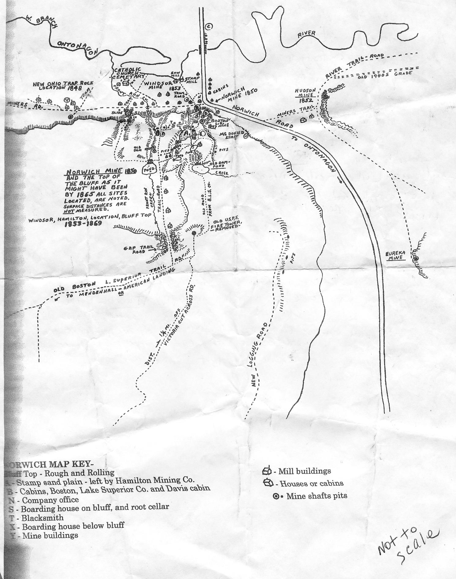
But holy crap was this one detailed—it showed about 20 times as many sites as the faded sign I had read yesterday! I about crapped myself when I thought that the gurus back at CCE had maybe never even seen this before—instantly I asked him if I could take a picture of the map, and before he said yes I snapped one anyway. It was hand-drawn by somebody, who knows how long ago, but it showed the locations of ghost towns and other stamp mills and things that I didn't know about, and stuff on the opposite side of Norwich Road even! I was practically giddy; I couldn’t wait to get this map photo back to camp and put it on my laptop so I could study it closer. The three of us stood in a circle for a few, pointing out things and making comparisons to what I had found or what I had thought was the case. Looking at this map I could not even reconcile the mental image I had of the simplesque USFS map from yesterday; it did not even seem to match up. My newfound friends were pretty impressed but taken aback that I was navigating merely by memory of that faded piece of crap, and a few rough verbal directions that had been passed to me.
I told them that I had not yet gone up top to see the actual Norwich shaft or adit, but that I knew where they would be based on ROC’s directions. They said it was absolutely incredible up there, and based on the panoramas I had seen thus far, I believed them. They also said that if I followed the trail to the left past where my car was parked instead of going down the Miner’s Trail, I could go right up the tailings pile. This was in fact what I had suspected was the case, but I had not yet gotten around to that part of the quest. I was taking small chunks to do in missions one at a time by area. Tomorrow I had basically decided would be the day I spend going all the way east on Miner’s Trail to follow all the ruins that lead off that way. ROC said that it wrapped along the base of the hill before curving north at the confluence of the Whiskey Hollow Creek and the South Branch of the mighty Ontonagon River until it eventually hit the Victoria Cross Cut Road, with ruins of dams and structures all along the way and out into the woods.
These two had gotten me all excited and I thought that I would probably scout out the climb of the cliff face as soon as I got back to my car, before the sun went down too far. We talked some more and the guy said that there was a line anchored there at the shaft mouth, and if I trusted myself to free-climb it I could enter the shaft; he said he knew of people who had gone down 1,100 feet into it. Rappellers doing that I could believe, yes, but I have no such gear nor much practice with it, aside from a couple times in Boy Scouts. Damn…1,100 feet! That’s insanity…I’m actually amazed that they could make it that far without suffocating. Then again ROC did say that you can feel cold air coming out of it, so it has to be pulling natural ventilation from somewhere. Who knows what’s all down there.

The sun was beginning to go down, so I let these friendly folks go about their quest and they let me go about mine, and I headed the last mile or two back down to my car. I quickly dropped my backpack and went ahead encumbered only with my knife and camera around past where the hippy couple had parked, and up into the tailings pile. Tailings are the smaller chunks of poor rock that spew down the side of a mountain (usually in a fanned-out formation), after having been extracted from the opening of a cliff-side mineshaft. Easy to spot from a distance, tailings piles are always a surefire way to spot mine sites when in the wilderness. However, they are usually very steep and treacherous, especially when containing loose skree (finer gravel), and you can tumble to your death or at the least some pretty grievous injuries.


As I rose above the trees, I could see the gorgeous rays of the setting sun casting the rich greenery of the pines in a golden aura. The incline I was on had to be 60 degrees in places; the only way I made it through the middle section was by grabbing onto the woody stems of oak seedlings taking root in the mountainside. I had to be damn careful not to put too much reliance on them, or on anything…if a handhold gave out, my foothold had to be sure enough to fall back on, etc. So you can't shift from a hold until you’ve tested the new hold. In other words, this was extremely slow going, and tiring. Not to mention whatever I climbed up—I had to somehow get back down (which is usually more strenuous and dangerous). But now I was committed; I had to go the full climb. I found it easier to clamber directly from sapling to sapling, though usually nothing grows in tailings. Finally I began to reach the foot of the bluff's actual rock face.
I rested. My boots were thrashed. Their soles were eaten through and I could see a split opening in the front of the sole on one. Luckily I had followed the tailings almost precisely to their point of origin, and the shaft mouth lay directly above me, but I couldn’t see it yet, and would still have to do some real rock climbing. However, looking up the vertical rock face I could discern the cleft in the mountainside where it likely lay nestled. My goal was within reach as soon as I could plot a safe course up to it, and regain enough strength to follow it.


I could not believe that such a mine still existed in Michigan…I had always been under the impression that all the copper shafts had been filled, covered, or were simply on flat ground. This was more incredible and awe-inspiring than anything I had seen in Colorado, and it was harder to find and harder to reach. I just could not stop gaping at the unbelievable sight that lay before me…my camera just simply was not good enough to convey the scale of this in these pictures. Here was the piece of 3/8 nylon line that whatever fools had attempted to descend this cave had attached to a birch tree (bottom of frame):


As I approached I could see that this mine seemed to have been neglected for longer; the pile was almost covered in fallen leaves, pine needles, and lichen. At the top of it I found another rocky shaft mouth though not as big as Norwich B, and I also noticed that unlike any of the other shafts I had thus far seen, it was not tagged, nor was it fenced off in barbwire…strange. I wondered if this was Norwich “A”…? Or perhaps it is one of the truly ancient mining pits?
Now that twilight was definitely impending I made haste to descend the cliff before I got caught in the dark. I was definitely trying not to descend a cliff face in the dark. I descended almost painfully, due to the fatigue in my legs. I made it to about the halfway point of the tailings slope when suddenly my heart froze in my chest as the utter silence of the twilit world surrounding me was violently shattered.

Unfortunately it was very much hand-drawn, and by the author’s own admission quite crude; he wrote on it “Distances are not measured,” etc., so I knew that I would have to take this with a very large grain of salt. This was reminiscent in a rather pleasing way of the primitive maps of the French voyageurs who first sailed the Great Lakes. “Here be Dragonnes…” As I would later find out, the map had been xeroxed from Joseph Papineau's book about the Norwich.
I found a pencil and started scrawling some thoughts down on the back of it, in diary form:
Am considering staying out here three more days…will/may need to return to Ontonagon to replenish provisions & recharge laptop for memory card dumping. As darkness falls & I am still awake, contemplating how beholden I am to the sun’s hours. Darkness is total. Have left: 2 tomatoes, most of granola, most of the korpua, some jerky. Will need water again ASAP.I had spent seven hours straight exploring. As much as I hated myself to do it, I chose to sleep inside my car as opposed to camping under the stars like I usually do; this area was basically surrounded in bog, and had the mosquitoes to prove it. And if I was going to be out here several more days it might behoove me to try and find some better comfort than the hard ground so that I am in top exploring shape. I had a feeling it would get pretty rough and that a few more cliff-climbs were in store. Plus the thing with the wolves…heh. The weather was gorgeous however, and it just killed me to have to hide inside my car. I had the clothing to easily deal with the cold night temps.
I awoke once to take a leak; the starry sky was absolutely stunning.
CLICK for part five.
Sources cited in this series:
http://www.coppercountryexplorer.com/explorations/mines/cliff-mine/
http://cliffmine.wordpress.com/history-of-cliff/
http://cliffmine.wordpress.com/2011/05/21/field-trips-part-1-the-norwich-bluff/
http://www.passportintime.com/summaries/96/mi96_ottawa_nwoods.html
http://www.mindat.org/loc-17462.html
http://www.mindat.org/loc-17100.html
Norwich Mine, An Historical Journey Across Time, by Joseph R. Papineau
A Guide to Michigan's Historic Keweenaw Copper District, by Lawrence J. Molloy
"The Copper of Michigan," New York Times, Oct. 14, 1890
"The Ontonagon Copper Rock," Sacramento Daily Union, Oct. 8, 1857
No comments:
Post a Comment
Note: Only a member of this blog may post a comment.