
CLICK to return to previous episode
On day three of the “Norwich Expedition” (Wednesday), I awoke early to another beautiful sunny but cool morning, and ate a breakfast of raw granola while studying the new map I had been gifted by the fickle gods of exploration and comparing it with the notes I had from ROC.
Today I would head out as planned on the Miner’s Trail east as far as I could go, seeking out what ruins might lay at the foot of Norwich Hill. Supposedly there was quite a stock of them, however the edge of my new map cut off most of that trail. I laced up the boots again, loaded food and spare clothes in my frame pack, and hit the trail for the day. As I set out, I crossed the Front Run Creek and filled up with water there.
On my map the first thing along the eastern way of Miner’s Trail past where I had already been was what's marked as a “rock slide”…at the top of which was a cluster of mines. This would be my first target of the day, since at the foot of the slope below it was a cluster of ruins that were once connected to the mines up top by a tramway, or so said the map’s legend, which dates the period captured by it to around 1865. Also I noticed that the side trail leading to the cemetery not only included a graveyard, but there had been a “catholic church” there too. Now, I checked out the cemetery pretty good on Monday; I didn’t remember seeing any church ruins…. Maybe if I got the chance I would head back over there and take a better look around, but it was a mile out of my way, over rather mushy mosquito-infested ground.
I hiked east on Miner’s for maybe a half hour, then on my left through the forest canopy the snippets of visibility that I got of the cliffs towering above showed me another tailings pile fanning down the mountainside. This I deemed would be my first adventure of the day and I was raring to go for a climb, but I had not seen any sign of ruins to my right on the lower side of the trail as the map indicated, despite my vigilant scanning of the tangled foliage and moss-carpeted boulders within. At first I kept my pack on as I ascended the lower tailings, since this pile seemed a little tighter-knit; being older and more overgrown, it was held together a little better and less prone to slippage. Also the rocks at the bottom were of a bigger size. Once I hit the bottom edge of the finer tailings I opted it was definitely wiser to leave the pack here and continue upward unencumbered.

From here on up it was much the same as the ascent last night, using small growth, shrubs, and trees to grab and pull my way up through the impossible spots, and take breaks every so often. By the time 30 minutes had passed, I had begun to get up to the foot of the vertical rocks again.
After a good long rest I started once again to plot out the easiest course up from where I was. I can’t convey how difficult this was at times. It was interesting teaching myself how to rock climb all over again; had I known this was what I’d be doing on this trip I’d’ve maybe practiced a bit beforehand. It took about another 45 minutes to climb, and in a couple spots I had stuff pull out on me. Luckily I was being cautious and didn’t put too much trust in any one hand or foot hold. I actually found a few eyries where either eagles or hawks had nested (I could tell by all the turds piled up in them).

At long last, clawing my way up over the edge I reached the top and almost instantly was confronted by a mineshaft cordoned off with barbwire. It was tagged as Windsor #3:

Now this was an open shaft if ever I saw one…the mouth (though much smaller than Norwich B) was fully visible, clear of obstruction, and seemed to go down into infinity. It was kind of scary to walk around it, knowing that one false step and you’d be tumbling down one very long drop…with absolutely no way to stop yourself (the angle on this shaft was again about 60 degrees, practically straight down). Definitely no Lewis Carroll novel at the bottom to cushion your fall either.

According to Joseph Papineau, the Windsor Mine was opened in 1853 by Captain Plummer, and soon sank a number of shafts on the Norwich Bluff, the deepest of which was the #4 shaft, at 530 feet. The Norwich was definitely the most important of the American Mining Co.’s several concerns in the area by 1853, but as Papineau states, dark clouds were looming on its financial horizon. The cost of operating a mine at such a desolate, remote location was starting to prove itself to be a massive financial burden, but the investors held out hope because the Soo Locks was planned to open by 1855, drastically reducing the cost of doing business.

I shot a short video clip with my camera of me tossing a rock down the shaft, and waiting ‘til I couldn’t hear the sound of it clattering downward anymore. It took a solid 30 seconds before the echoes stopped, though it might've just went out of my hearing range. Hell, for all I know that thing is still falling as I type this. All I know is I didn’t hear a splash. What a trip…it was like staring down into one of the very pores of the Earth.

I started to look along the bluff in an easterly direction for the next shaft. I found it soon, maybe 50 yards away, the Windsor #4. Looking at my map I could see that there were only four Windsor shafts, so in order to find the remaining two, I would have to head the opposite direction, since mine shafts are almost always numbered consecutively along the lode.

Better view down into it:

I backtracked to the #3, perched so precariously at the edge of the mountain, with such a striking view out over the great distance. There was so little ground to stand on here between the shaft and the sheer drop off the cliff that I scarcely knew how anyone could work here safely. Once again there were no structures to be found, only the tailings and the shaft mouth itself.
Other than the Norwich B, this #3 was undoubtedly the most striking and picturesque location I had yet found. I milled about for some time here again just marveling at the gaping chasm that descended into the chilling depths of the mountain, mere feet from a 30-story drop to the forest below. As I putzed around I noticed that the poor rock immediately to the left of the mouth seemed to take on an irregular pattern; there seemed to be a formation like the foundation of a building, perhaps, that once upon a time would’ve sat directly next to the shaft collar. I could discern two corners seemingly, of piled stone and of course a dead pine tree and other things that had grown out of it or in it during the fifteen interceding decades that it had perhaps lain unused:

I could picture the hard-bitten, bearded prospectors ambling about this site under their faded broad-brimmed hat and soiled breeches in the hot August sun, much as I was doing today.
There was a small economic panic in 1854, and Papineau writes that when the ship carrying some of the winter supplies the Norwich had ordered sank after leaving Detroit, they were forced to stop mining by January and the company was in debt $70,000. Worse yet, they were unable to pay their miners, who generally don’t take that kind of thing well.
Alonzo Davis, captain of the mine, managed to secure enough credit locally (through, perhaps, other than ordinary means) to keep the mine going through the winter, and at least stave off the liquidation of their land and equipment (and a mutiny by the men). On board the first ship to make it through the lake ice in spring to Ontonagon were the two Norwich directors, who came all the way from Vermont with cash in hand to pay the miners. The buildup of ore waiting to be shipped could now be sent to the smelter in Detroit, and then on to New York for sale, and all was well again. At least for a year anyway.
It took me another 20 minutes of bushwhacking along the cliffs to locate #2 Windsor. When you’re doing this you have to be very cognizant of your surroundings; you never know when you’re within inches of falling into a death trap unless you can recognize the warning signs…just because some are marked by the Forest Service, doesn’t mean they all are. Or they may have been marked—20 years ago—and no one has been back since…as was apparently the case here:

Any time you are walking along in the woods and you step across any kind of fencing or barbed wire, no matter how crushed and buried in the underbrush, take note. It could likely be your only clue that a shaft is near.

You must be able to analyze all your surroundings; sometimes "capped" shafts are covered in debris, and can easily cave in again, dragging you down into the bowels of Hell. Which is why I am not a fan of capping mine shafts—it disguises them, and cap jobs almost always weaken and fail after enough time has passed. At least if the holes are left open, it makes them easier to see.

I finally found the #2, coming up from behind:

Less impressive than the previous two, it nonetheless was a formidable hole in the ground.

The #1 was just as hard to find, but when I did I saw that it was completely flooded up to the mouth and also infested with thick globs of algae:

Up here among the Windsor shafts, it seemed as though the true finds were to be had on top of the mountain, not below, and made me wish I had kept my pack with me instead of leaving it at the bottom, but I had to stick to my set mission in order to properly and efficiently cover the entire Norwich area. I had planned to do a better exploration of the top one day later this week.
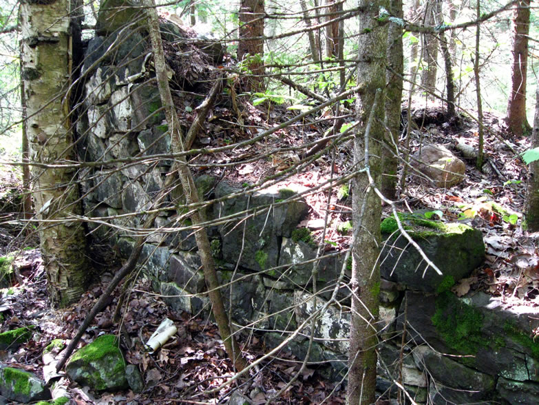
I took my time in descending the mountain again; it was much less fun to go down than up. The stress on the muscles and joints is considerable. Overall I had invested several hours in this first "mission" of the day. Upon reaching the bottom again I continued my eastward trek, and soon came across a shape in the woods that sent up mental flags—ruins!

It was a long straight horizontal line, covered in moss and lichen, apparently part of a foundation. Scanning the woods nearby in greater detail I could tell that more was hidden. I dropped my pack next to the trail and made ready to bushwhack again.

The mosquitoes were as ferocious as ever, and I now fully wished that I was doing this in October…for Yoopee ruins hunting, that is officially the best month—the cold knocks the bugs down, and the leaves are mostly off the trees, increasing visibility. Also you can wear heavier clothing, protecting you from scratches incurred by pushing into dense brush where only the foxes should go.

This must be the Windsor Mine’s base of operations. I could see where the former dam had been (an old iron pipe was present, perhaps added to drain it):

In April 1856, the Norwich stamp mill, sawmill, and a few other buildings by the river were destroyed by a fire, Papineau writes. Thankfully the men were able to get enough water onto the stamps to keep them from melting, and the company could still operate the mill without walls or a roof. Despite these problems, Norwich still produced 116 tons of copper that year, but much of it accumulated in piles waiting to be stamped. The new stamp mill was completed in a year, and ran full blast to get caught up on the backlog of ore, and to pay off the mine’s debt.
The recession that started in 1854 had deepened into a depression all across the Copper Country by 1857, and many mines, except for the legendary ones like the Cliff Mine and Minesota Mine were forced to close. On June 1, 1857, the American Mining Co. suspended all operations at Norwich and Windsor, while the Hudson Mine had already been closed for three years. Tribute miners were allowed in to the Norwich to see what they could dig up, and though a good amount of copper came out, they were forced to stop before winter, and the remaining families moved away, except for two who were designated as caretakers in exchange for free rent. The winter of 1857-58 turned out to be one of the coldest ever recorded, with temps down to the -40F mark, crushing snow, and spring a month late.
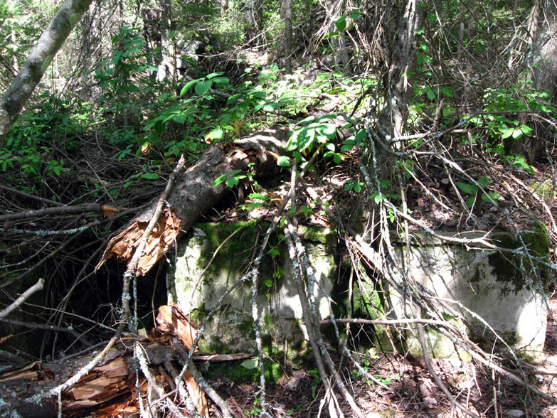
I was finding both poor rock and concrete foundations here, indicating that the Windsor had a longer run of operation than some of its nearby cousins, since I don't think there was a means to make concrete here until around the turn of the century.

Either that, or the newer concrete vestiges were evidence that the mine workings had been re-explored to some extent in modern times by other companies, using more advanced technology.

But overall there still were not as many ruins here as I was hoping for, however.
Norwich tried tribute mining again in 1858, but only 19 tons of copper was found, as most of the easy masses had already been brought up. In the ten years that the Norwich Bluff was being worked, Papineau notes that the company was always in some financial trouble or other—despite showing promising product—and it was mostly due to their distance from Lake Superior and lack of good roads to transport their work to the docks. The owners never could quite invest what they needed to into the mine for capital improvements, and therefore it was always hampered by its remoteness.
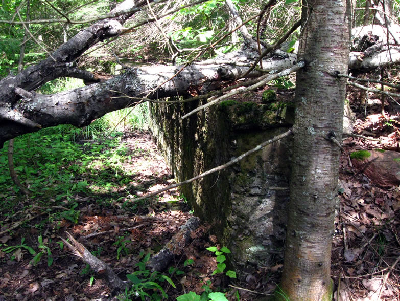
This particular ruin was intriguing, in that it still had pieces of apparently hand-hewn wood fastened to it by huge bolts:

If you were to look closer, you can see the marks on the planed face of the wood where it had been fashioned by axes or crude sawmilling (sadly not visible in the photo):

Here were the concrete footings to some kind of heavy compressor or (electric?) motor, seeming to indicate a more modern operation than is suggested by the sparse ruins present:

In an effort to regenerate momentum in the stagnated war to preserve the Union the government took up a new cause in 1863, that of emancipating the southern slaves, and the price of copper jumped again, to over 30 cents per pound according to Papineau. The lure was enough to spur another reorganization of the Norwich Mining Co., at which time the Windsor Mine was absorbed into the Norwich Co., since it never was an impressive producer on its own, having produced only 38 tons in four years.

The problem was, even though the price of copper got up to around 55 cents per pound, with the certainty that the Civil War would come to an end soon copper prices begin to plummet back to 26 cents, and so did shareholder interest in the mines. In July of 1865 the Norwich Post Office closed, and the steam hoist engine burned down. The replacement would've costed $1,000, but with copper prices still falling and the mine’s prospects no better than before, the company decided not to replace it. Tribute miners were again called in, but by the end of 1869, all the mines on Norwich Bluff were silent. All the families left except for a couple that decided to farm the land.
Mindat.org has a slightly different version of the story:
In 1863, the [Norwich] company was reorganized and consolidated with the Windsor Mining Co. In 1864, the company merged with the Hamilton Mining Co. The mine was closed in 1865, but work continued on tribute until 1869. In 1899 and 1900, some work was done at Norwich under the name of Essex Mining Co. The mine produced an approx. total of 993,000 lbs. of refined copper."Tribute" mining, by the way, is when they lay off most of the work force and allow the most skilled miners back to work the drifts on their own with no set plan, who are paid not by the day, but based on how much copper they bring out. Basically it is a move that equates to the retrieval of whatever low-hanging fruit might still be available, and can result in a haphazard mess inside the mine. It's something that is generally only done as a last-ditch effort when a mine is considered to be basically tapped out.
By the late 1870s the Norwich’s physical plant was showing deterioration, and some of its buildings may have been disassembled for salvage, or to be relocated elsewhere. The occasional vagabond, squatter, or hunter took up residence there at times, but other than that it was a ghost town. In 1885 a New Yorker named Marmaduke Richards bought the property, who Papineau states “just wanted the satisfaction of being able to say he owned the Norwich, a great copper mine in the Northern Michigan wilds,” illustrating just how well known it was at one time. In 1895 there were still 30-40 dilapidated buildings standing, and only two families were living there, the O’Rourkes and the Fergusons, who were farming.
In the early 1900s a Judge Mahoney of Minneapolis bought the Norwich, and immediately sold it to the Copper Crown Mining Co. of St. Louis, which in 1902-04 attempted to reopen it, the Hamilton, and the Lafayette Mine (in the Porcupine Mountains). They repaired a few buildings, and did some adit work, and plannned to build a new stamp. They drove a new adit 430’ into the bluff but never got any further before giving up; the Norwich was abandoned for another ten years.

In the 1930s, the site was denuded of all its structural iron for scrap, the dilapidated wooden structures were torched, and the adits were blasted with dynamite to close them. Norwich was finally done for good. Papineau asserts that “it was its inaccessibility and the companies’ attempts to save money,” along with a lot of bad luck, that doomed the Norwich to becoming just another big money pit. The owners of the Norwich and countless other such failed mines, Papineau says, “were always too shy when it came to spending money to mine, especially when the copper is probably there.”
Norwich’s final tally came in at 498.5 tons of copper, and yet was only delved to a fourth level—a very shallow mine by Copper Country standards. Clearly there are winners and losers in this business; the Cliff was a winner, and the Norwich was a loser, though they both had a pretty equal fighting chance at success in the beginning.

However I was not in the mood yet for another strenuous climb; such would wear me out for the rest of the day and it was not even lunchtime yet. I used a couple sticks to mark an arrow on the ground where I felt would be the best way to approach the cliff when I returned later, and continued down my original path. I was not seeing anything in the woods…this distressed me a little bit, especially when I came to the southern fork in the road and still had seen no ruins:

After about 20 minutes of walking I came to a clearing and noticed that there was a building up ahead—a cabin! Holy crap, I was in somebody’s driveway. Upon further inspection it seemed no one had been here in a while, and it was probably just a seasonal hunting lodge. Nonetheless I turned around and met up with the main trail again. ROC had said that this trail goes to the confluence of the South Branch Ontonagon and Whiskey Hollow Creek, before bearing north. That should be a fairly easy directive to follow. I forged ahead and started seeing more frequent elevation changes, and many parts where the trail likely washes out in spring from mountain brooks draining the thaw. The trail I was walking was still wide and clear.


That’s alright; this leg of the trek seemed to be a wash anyhow; I had not seen any ruins at all since the Windsor Location, and even they were sparse. I decided that here would be an ideal place to break for lunch. I walked back to the cabin and set my pack down on the shaded porch, and drank the cool water I had drawn from the creek. I noticed that so far I had consumed exactly one half of the Trenary Toast in two meals…meaning that I basically had two meals left in the bag. I pulled out the map and the pencil again and jotted some more thoughts on the back of it.
Including the remaining granola, jerky, and last tomato, I have about three more meals left…four if I stretch it, and exert myself less. Found a very Deliverance-esque hunting cabin…Nearby to the porch was a deer gallows, with block & tackle hanging from a crossbar that had been hewn out of a tree limb and lashed to some others to make a frame, with a ladder going up one side:


This tailings climb was a little harder being that I was already tired, so it took some time. When I finally reached the foot of the vertical solid rocks, I was thwarted for quite some time; I could not find any viable way up from where I was at. Long I struggled in trying to get myself up, but either I had picked a very bad spot to ascend to, or there just was not a way up. I was dog-tired, it was about 4pm, and I was sweaty and sore. I sat for a long time on my tiny perch in the shade, looking up at the jagged overhang straight above my head, cursing my situation.

When I reached it however, I discovered that it was a false hope, the shape of the rock and the ground beneath it merely took on the appearance from below of a shaft mouth’s presence. Onward a little further I could see a more pronounced cleft in the mountain, more akin to the Norwich B’s perch; this had to be it—I could see tailings kept going up the mountain over there as well. I made the strenuous journey over to it, and risked the even more dangerous and strenuous scramble up into it, but the closer I got the more I could tell that this too was a fake-out.
I stopped and looked up further through the dense trees, guessing that the source of the tailings had to be on a cliff still higher yet than I could even see, but I was now running on empty and was facing a positive bitch of a climb back down this beast. Not to mention I had to find my water bottle first. But I needed a serious rest before doing anything. I found a broken tree to sit on, and pulled my boots and socks off to air my sweltering feet out. I sat for another half hour trying to rest as much as possible. By the time I made it back down to my backpack, the sun was beginning to mellow into the west and cast more slanted, more golden rays through the dancing leaves of the cool forest. There were still—according to the map—more things to check out tonight (on level ground!) that I could investigate after drinking that last KBC and leaving my pack at the car.
I rolled into my base camp at about 7:30pm, having been out for a total of eight and a half hours. The map said that if I walked down Norwich Road south a ways and hooked a left just before crossing the Ontonagon River, I could find where there had been a sawmill and a stamp mill. I’ve never checked out a sawmill before so I hoped that this one still existed, especially considering Michigan’s glorious past relationship with them. I set out unencumbered down the paved road, enjoying the easy going. However to my left where these mills would be was nothing but dense wetland, and I saw no ingress at all along the whole thing until I reached the pier of the bridge spanning the wide river. There it looked as though people liked to pull off the road to fish because there was a faint two-track leading through the tall grass. I followed it as far as I could before it bogged down in a bunch of reeds, and saw that there was a large patch of sand below me, forming a bend in the river. Was this a stamp sand?

By my estimate there is but two days of work left here; Hudson and Eureka, and a better coverage of up top. I don’t know if I can climb the face again…if I go around behind via the North Country Trail and Forest Service Rd. it will be flatter, but it’s going to mean a lot of bushwhacking and dead reckoning.I ate dinner, finishing off the last tomato. Tomorrow I would hike out north along Norwich Road, take the North Country Trail up the gentler backside of the hill to the fire tower, and from there navigate to the area of the Norwich B again so that I could get photos of the mystery shaft above it that I wasn’t able to before. Friday would be my last day, and it seemed logical to allot an investigation of the west side of Norwich Road for that day to seek out the Hudson and Eureka Locations. Once again I had to swallow my pride tonight and sleep in my car, but tomorrow night I would sleep up top—something I had been wanting to do since I got here.

Sources cited in this series:
http://www.coppercountryexplorer.com/explorations/mines/cliff-mine/
http://cliffmine.wordpress.com/history-of-cliff/
http://cliffmine.wordpress.com/2011/05/21/field-trips-part-1-the-norwich-bluff/
http://www.passportintime.com/summaries/96/mi96_ottawa_nwoods.html
http://www.mindat.org/loc-17462.html
http://www.mindat.org/loc-17100.html
Norwich Mine, An Historical Journey Across Time, by Joseph R. Papineau
A Guide to Michigan's Historic Keweenaw Copper District, by Lawrence J. Molloy
"The Copper of Michigan," New York Times, Oct. 14, 1890
"The Ontonagon Copper Rock," Sacramento Daily Union, Oct. 8, 1857
No comments:
Post a Comment
Note: Only a member of this blog may post a comment.